We present the UTUAV dataset which consists of three different scenes captured in the second largest city of Colombia: Medellín. Road user classes representative of those in emerging countries such as Colombia, have been chosen: motorcycles (MC), light vehicles (LV) and heavy vehicles (HV).
The dataset was initially annotated by means of Viper
annotation tool. Subsequently, the annotations were converted
to the Pascal
VOC (XML) format (directories named "Annotations",
bounding boxes in absolute coordinates xmin, xmax, ymin, ymax)
and to Ultralytics
YOLOv8 format (directories named "labels", class label
(0: motorbike, 1: LV, 2: HV followed bounding boxes in
normalised xywhcoordinates relative to image width and height:
xcentroid, ycentroid, width, height). The images are stored in
directories named "images".
Publications:
If you use these datasets please cite the following publication:
@article{felipe2025utuav,
  title={UTUAV: A Drone Dataset for Urban Traffic Analysis},
  author={Felipe, Lepin and Velastin, Sergio A and Le{\'o}n, Roberto and Jes{\'u}s, Garc{\'\i}a-Herrero and Rojas-Mart{\'\i}nez,
Gonzalo and Espinosa-Oviedo, Jorge Ernesto},
  journal={Drones},
  volume={10},
  number={1},
  pages={15},
  year={2025},
  publisher={MDPI AG}
}
@article{espinosa2020detection,
  title={Detection of motorcycles in urban traffic using video analysis: A review},
  author={Espinosa, Jorge E and Velast{\'\i}n, Sergio A and Branch, John W},
  journal={IEEE transactions on intelligent transportation systems},
  volume={22},
  number={10},
  pages={6115--6130},
  year={2020},
  publisher={IEEE}
}
Researchers can use these datasets provided that is only for
research, not commercial, purposes. To access these datasets
please contact Prof.
Sergio A Velastin with your name, institution and purpose
of your research.UTUAV-A Dataset (road side)
This dataset corresponds to an extension of Espinosa et al. dataset, which originally only contained annotated motorbikes in 10,000 frames with a resolution of 640x364 pixels. The images were taken from an unmanned air vehicle (UAV), elevated 4.5 meters from the ground. The UAV is kept at the same position and small movement of the camera is noted. The extension includes the annotation of light and heavy vehicles. The following table presents the main dataset characteristics, including the number of annotated vehicles, mean area of the vehicle bounding box, total occluded vehicles, the mean duration of total occlusions measured in frames and the mean displacement in pixels of objects when are occluded. Note that due the limited elevation, and the capture angle of the sequence, occlusions appear frequently, and object sizes changes significantly.
(NB: the numbers are indicative only as they might be
slightly different to the final annotations, in this case
there are 10,050 images)
| Vehicle | Motorcycle | Ligth Vehicle | Heavy Vehicle |
|---|---|---|---|
| Number of annotations | 56970 | 44415 | 44415 |
| Annotated objects | 318 | 159 | 16 |
| Mean Size (pixels) | 1.763 | 4.546 | 4.771 |
| Totally occluded objects | 7 | 6 | 3 |
| Mean occlusion duration (frames) | 8.1 | 2.9 | 269.3 |
| Mean occlusion displacement (pixels) | 31.2 | 6.3 | 369.4 |
Fully
annotated dataset
Dataset split
80:10:10 into training, validation and evaluation
sub-sets. This also contains json files in COCO format that we
have used to train and evaluate DETR models.
Bird-eye Datasets
Currently, we are concentrating on the following two sets
("B" and "C") which are of bird-eye views of urban
traffic taken from two different (but similar) heights for two
different road topologies. These sets are usseful to
experiment with:
- Detection methods able to detect both very small and larger objects.
- Measuring generalisation capabilities e.g. how a model trained on B performs with images from C and vice versa.
Global Data
When you download these datasets, you will find the following sub-directories:
- Visualise: The images with added bounding boxes on the annotated objects (each class shown with a different colour)
- Annotations: The annotated objects in XML-encoded Pascal VOC format (absolute image coordinates)
- images: the jpeg images of that dataset
- labels: the YOLO (Ultralytics)-formatted annotations (ground truth) for those images
- You might also find files
- *.xgtf: original annotations in Viper-GT format (historical)
- default_copy.yaml: hyper parameter configurations for YOLO (Ultralytics) training
- X_Dataset.yaml: X=B or C, Ultralytics definitions of file locations (train, val, test) and classes
- Note that the downloadable datasets contain ALL images and labels (annotations) without distinguishing between training, validation and testing sub-sets. These are defined by "partitions" as explained below.
New! (April 2026): Annotations for static vehicles and vehicle ids for tracking
We are now providing annotations for previously non-annotated
stationary vehicles (thanks for Claudio Inal from Universidad
Tecnica Federico Santa Maria, Chile). These are offered in two
ways:
- Explicit separate classes for static motorbike, static cars and static buses (large vehicles). This way, the datasets contain 6 clases (including the non-stationary vehicles).
- Since detection training and inference is likely to be based on static separate images, we also provide annotations where the stationary classes have been "merged" into their corresponding classes (e.g. stationary motorbikes simply into motorbikes).
We now provide data in the following formats:
- Traditional YOLO (Ultralytics) "labels" normalised
cooredinates format (class centroid_x, centroid_y, width,
height), one file per image
- XML pseudo Pascal VOC format where we have added
attributes "track_id" (a unique number for each vehicles as
they go from one frame to the next) and "occlusion" (always
the same!, for future annotation refinement), one file per
image
- MOT format (as per the MOT challenge). A single file of
comma separated rows for each image: frame_id, track_id,
top_left_x, top_left_y, width, height, confidence (always
1), class_id, visibility. These files have been generated
from the pseudo Pascal VOC files.
Data Partitions
This refers on how the data is partitioned into training,
validation and evaluation (test). We do not mix B with C as
one of the purposes it to check generalisation (see above).
Originally, we "naively" created such partitions by random
selection of frames. This however tends to "inflate"
evaluation metrics because the trained model had been exposed
to similar images. This is aggravated by the fact that images
come from temporal sequences (videos). So, we provide the
following partitioning schemes:
- Original: Where train/val/test frames were randomly selected from the global data (separately for B and C). This is mainly of historical interest.
- We then first separate an evaluation (test) sub-set consisting of the last temporal segment of the video sequence. The same evaluation sub-set is used for all tests (for different partitions, except from "Original"). Then training and validation sub-sets are provided using the following approaches:
- Random: where training and validation images have been randomly selected from the remaining images
- Sequential: where the training sub-set is extracted from the start of the video sequence up to a point in time where there is a given proportion of these frames. Then the frames that follow (after the evaluation set was extracted) form the validation sub-set
- Sequential_gap: Where we drop a number of frames (100) around the dividing line between training and validation frames and between the validation and the evaluation frames.
- Sequential_gap_300: As above, but with a gap of
300 frames between train/val and val/eval frames. This is
the data we used in our Drones
paper and what we recommend to be used as a
baseline. The other possible partitions have been left as
historical records.
- These data partitions are stored as simple text files (e.g. training.txt) that contain a list of image files
- The partitions for the B dataset are stored in a directory
B_Split and those for C in C_Split
Note
for Chrome/Chromium users: Chrome's automated
scanner may flag this small metadata archive as an "uncommon
download." The file is perfectly safe. If blocked, please
right-click the link and select "Save link as...",
use Firefox, or download via terminal: wget [URL]
(Note: we use terminology such as "B_Sequential_Gap300Stat"
to indicate: B dataset, Sequential_gap_300 partition, Stat: 6
clases, and "B_Sequential_Gap300Stat" for 3 "merged" classes).
To generate Ultralytics-compatible images and labels
directories using the above text files and the global
datasets, we provide the python script: GenDataset.py (it
works in Linux and by default it creates symbolic links to the
original global files to reduce storage requirements). The
script can be downloaded from here.
Segment GTs
We have also generated "segment" GTs compatible with
Ultralytics (each object is represented by a polygon
corresponding to the segment contour). We have done this using
Meta's SAM
(version 1, perhaps later versions produce better results?).
As per the normal (bounding box) annotations, the "labels"
directory for segment GT contains the GT all the images. You
will need to then separate these into training, validation and
evaluation for a given partition (we recommend the
Sequential_gap partition). Note that this has NOT been done
for Sequential_gap_300.
Oblique Bounding Boxes (OBB) GTs
By using SAM-1, we have generated oblique bounding boxes (OBBs) for researchers to test if these provide better results than traditional bounding boxes. For more details see Ultralytics Documentation for OBB. (Thanks to UC3M's student Luis Garrido for doing this transformation). Note that this has NOT been done for Sequential_gap_300.
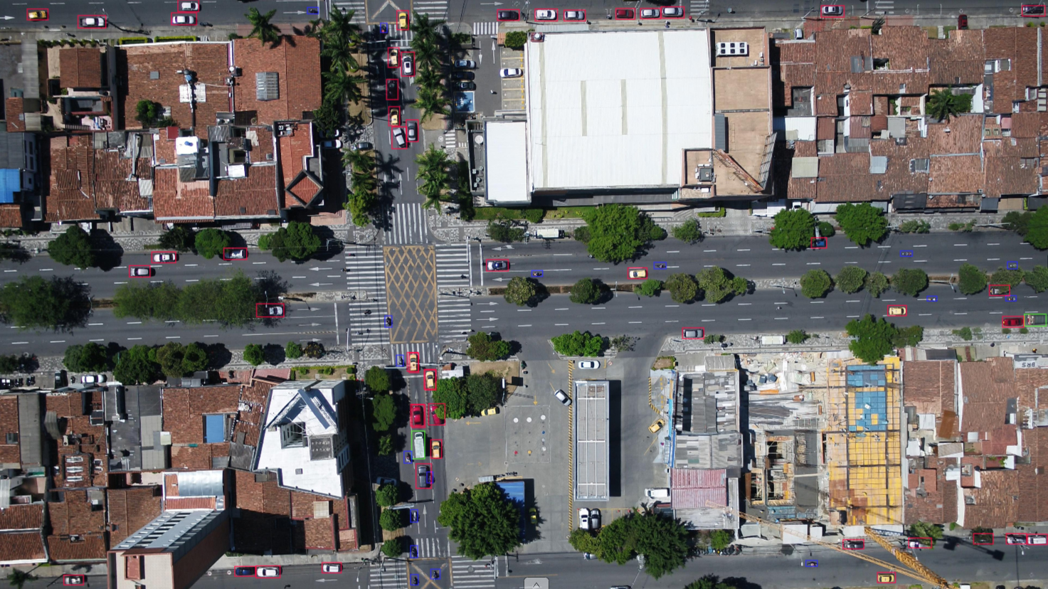
UTUAV-B Dataset
Exploiting the top view angle that a high elevation UAV could reach (approx 100 meters), the second dataset is composed of 6,500 labelled images with a resolution of 3840x2160 (4k) pixels. The entire sequence is captured with a top view and turbulence or camera movement is hardly perceived. The visualisation colors for the annotated bounding boxes (see pictures below) are red for light vehicles, blue for motorbikes and green for heavy vehicles| Vehicle | Motorcycle | Ligth Vehicle | Heavy Vehicle |
|---|---|---|---|
| Number of annotations | 70,064 | 331,508 | 18,864 |
| Annotated objects | 128 | 282 | 13 |
| Mean Size (pixels) |
992 |
3,318 | 5,882 |
| Totally occluded objects | 80 | 84 | 4 |
| Mean occlusion duration (frames) | 19.6 | 18.6 | 34.0 |
| Mean occlusion displacement (pixels) |
108.4 |
130.7 | 197.5 |
 |
Segment GT dataset (99MB)
OBB GT dataset (5.3MB)
New (3- and 6-classes, detection and tracking) (57 MB) (images are downloaded using the "Full" link above)
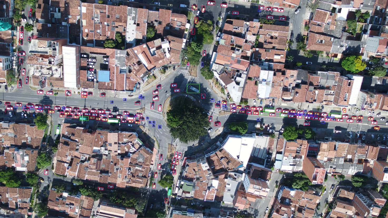
UTUAV-C Dataset
The third dataset was a sequence of 10,560 frames, of which 6,600 are annotated, with a resolution of 3840x2160 (4k) pixels. This video sequence was also captured from an UAV, elevated at 120 meters from the ground. The road configuration is different. These differences have been introduced intentionally to test generalisation ability e.g. of detection on this dataset using a model trained with UTUAV-B. This dataset also uses a top view angle and uses the same color code for annotations as per UTUAV-B.(NB: the numbers are indicative only as they are different to the final annotations, in this case there are only 6600 annotated images)
| Vehicle | Motorcycle | Ligth Vehicle | Heavy Vehicle |
|---|---|---|---|
| Number of annotations | 463,009 | 1,477,287 | 130,142 |
| Annotated objects | 456 | 997 | 86 |
| Mean Size (pixels) | 467 | 1,722 | 4,275 |
| Totally occluded objects | 211 | 265 | 31 |
| Mean occlusion duration (frames) | 89.9 | 86.8 | 110.8 |
| Mean occlusion displacement (pixels) | 226.9 | 210.1 | 260.3 |
 |
Segment GT dataset (226MB)
OBB GT dataset (14MB)
New (3- and 6-classes, detection and tracking) (143 MB) Note: 3-classes not including stationary vehicles (images are downloaded using the "Full" link above)
Baselines
Our latest set of experiments compares Yolov11N and ACD-DETR (also N) for the 3- and 6-class cases for the B and C datasets (Sequential_Gap300). In all cases we use imgsz=1024 and 100 epochs. Settings:- Configuration file
- A sample command to train a YOLOv11N model (change the paths as per you case)
- A slightly modified script to train an ACD-DETR model
- A script to generate predictions
and performance metrics for YOLOv11 models (it might
need scripts from here)
- A script to generate predictions and performance metrics for ACD-DETR models (it might need scripts from here)
clone https://github.com/TYrant-TY/ACD-DETR
cd to the new directory
Setup a conda environment (sergio_rt) as explained in the repo
python setup.py install
pip install psutil # else command “yolo” fails
pip install ipython # more friendly python console
To use an ACD-DETR “N” model (for fair comparison with YOLO N models), copy the file ultralytics/cfg/models/rt-detr/ACD-DETR.yaml to ultralytics/cfg/models/rt-detr/ACD_DETR-n.yaml and modify to (adding the scales for an N model):
scales: # model compound scaling constants, i.e. 'model=yolov8n-cls.yaml' will call yolov8-cls.yaml with scale 'n'
# [depth, width, max_channels]
n: [0.33, 0.25, 1024] # Add this for YOLOv11 N comparison (SAV/Gemini)
l: [1.00, 1.00, 1024]
Please feel free to contact me if there is something missing in these instructions.
Results:
B 3-class ACD_DETR
Class Images Instances Box(P R mAP50 mAP50-95):all 975 92427 0.978 0.974 0.986 0.711
m 975 19363 0.968 0.933 0.97 0.603
c 975 70193 0.973 0.997 0.994 0.781
b 975 2871 0.992 0.99 0.995 0.75
B 3-class YOLOv11N model
Class Precision
Recall mAP50
mAP50-95
all
0.946
0.898 0.927 0.718
m
0.870
0.701 0.792 0.440
c
0.982
0.998 0.995 0.868
b
0.985
0.995 0.994 0.845
B 6-class ACD_DETR
Class Images
Instances
Box(P
R mAP50 mAP50-95)
all
975
92427
0.981
0.972
0.988 0.735
m
975
10440
0.972
0.932
0.967 0.539
c
975
31621
0.971
0.992
0.994 0.756
b
975
2871
0.992
0.991
0.995 0.775
ms
975
8923
0.981
0.945
0.989 0.759
cs
975
38572
0.99
0.999
0.995 0.847
B 6-class YOLOv11N
Class Precision
Recall mAP50
mAP50-95
all
0.932
0.875 0.916 0.673
m
0.833
0.745 0.813 0.368
c
0.971
0.995 0.994 0.798
b
0.981
0.993 0.994 0.821
ms 0.892
0.643
0.784 0.498
cs
0.982
0.999 0.995 0.879
bs [there are no
static buses in this dataset]
C 3-class ACD_DETR
Class Images
Instances
Box(P
R mAP50 mAP50-95)
all
990
252991
0.947
0.902
0.931 0.688
m
990
43094
0.876
0.745
0.813 0.398
c
990
196118
0.98
0.982
0.989 0.812
b
990
13779
0.986
0.98
0.989 0.854
C 3-class YOLOv11N
Class
Precision Recall
mAP50 mAP50-95
all
0.857
0.768
0.799 0.599
m
0.648
0.332
0.411 0.148
c
0.960
0.977
0.991 0.789
b
0.965
0.996
0.995 0.861
C 6-class ACD_DETR
Class Images
Instances
Box(P
R mAP50 mAP50-95):
all
990
252991
0.969
0.934
0.954 0.739
m
990
43094
0.883
0.747
0.815 0.386
c
990
111501
0.982
0.969
0.983 0.719
b
990
9819
0.988
0.975
0.986 0.812
cs
990
84617
0.997
0.981
0.99 0.871
bs
990
3960
0.997
0.997
0.995 0.909
C 6-class YOLOV11N
Class Precision
Recall mAP50
mAP50-95
all
0.905
0.848
0.872 0.680
m
0.666
0.298
0.393 0.138
c
0.939
0.966
0.983 0.700
b
0.948
0.990
0.994 0.820
ms [there are no
annotated stationay motorbikes in this dataset]
cs
0.979
0.984 0.993 0.842
bs
0.993
1.000 0.995
0.899
For any queries related to these datasets
please contact Jorge
Espinosa or Sergio
A Velastin